Neighborhood Mapping

 Before 1938    –  Buying on Contract     Covenants  –   Covenant Database   –  East Bakersfield     

    Education    –   Eminent Domain     –     Moving into a Neighborhood   –    Neighborhoods     

 Public Housing   –  Resources    –   Rumford Fair Housing Act     Suburban Expansion   –   Zoning 

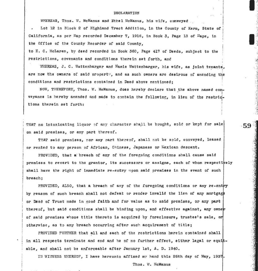
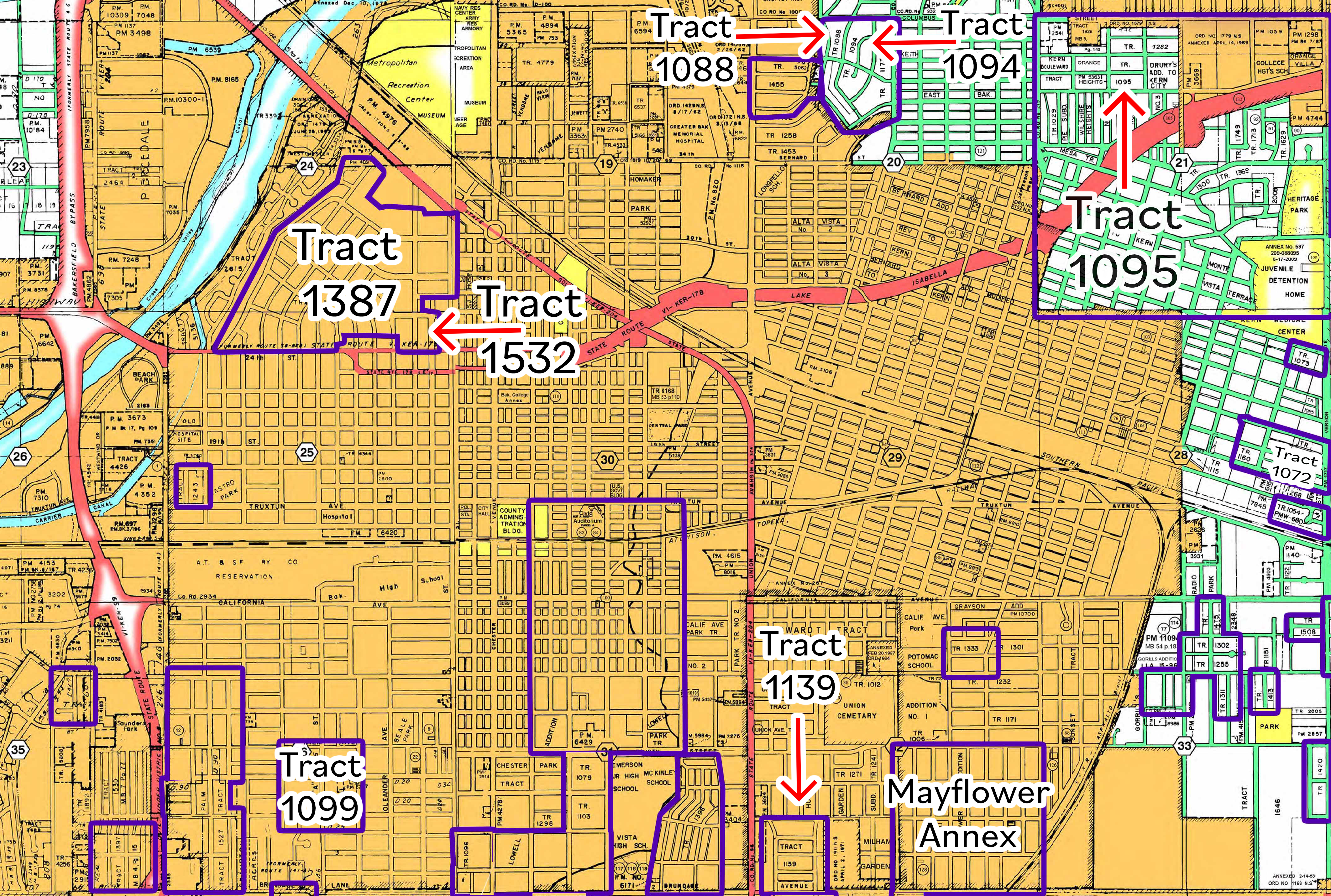
This map only represents a few of the racially restricted (white only) neighborhoods, including the suburban expansion of East Bakersfield and Southwest Bakersfield. This is only meant to be a small representation of all the 218 racially restricted neighborhoods in Kern County from 1938 to 1950. The 12-year period started when the Federal Housing Administration (FHA) recommended using restrictive covenants, including race restrictions. Real estate agents, including realtor professional associations, also recommended the use of racially restrictive covenants in their manuals. The practice of using racially exclusive language ended in 1950 when the FHA announced that it would not finance loans with racially exclusive language. This was a result of Shelley v. Kraemer, a Supreme Court case that stopped the use of racially restrictive covenants and found the legal language violated the equal protection provision of the Fourteenth Amendment. This period also includes the beginning of the postwar suburban Bakersfield.

WHEREAS, Thos. W. McManus and Ethel McManus, his wife, conveyed Lot 12 in Block 2 of Highland Tract Addition, in the County of Kern, State of California, as per Map recorded December 7, 1916, in Book 3, Page 13 of Maps, in the Office of the County Recorder of said County, to E. C. McLaren, by deed recorded in Book 360, Page 417 of Deeds, subject to the restrictions, covenants and conditions therein set forth, andWHEREAS, J. C. Wattenberger and Mamie Wattenberger, his wife, as joint tenants, are now the owners of said property, and as such owners are desirous of amending the conditions and restrictions contained in Deed above mentioned; NOW, THEREFORE, Thos. W. McManus, does hereby declare that the above named conveyance is hereby amended and made to contain the following, in lieu of the restrictions therein set forth: THAT no intoxicating liquor of any character shall be bought, sold or kept for sale on said premises, or any part thereof. THAT said premises, nor any part thereof, shall not be sold, conveyed, leased or rented to any person of African, Chinese, Japanese or Mexican descent. PROVIDED, that a breach of any of the foregoing conditions shall cause said premises to revert to the grantor, its successors or assigns, each of whom respectively shall have the right of immediate re-entry upon said premises in the event of such breach; PROVIDED, ALSO, that a breach of any of the foregoing conditions or any re-entry by reason of such breach shall not defeat or render invalid the lien of any mortgage or Deed of Trust made in good faith and for value as to said premises, or any part thereof, but said conditions shall be binding upon, and effective against, any owner of said premises whose title thereto is acquired by foreclosure, trustee’s sale, or otherwise, as to any breach occurring after such acquisition of title; PROVIDED FURTHER that all and each of the restrictions herein contained shall in all respects terminate and end and be of no further effect, either legal or equitable, and shall not be enforceable after January 1st, A. D. 1940. IN WITNESS WHEREOF, I have hereunto affixed my hand this 26th day of May, 1937. Thos. W. McManus
“That said premises, nor any part thereof, shall not be sold, conveyed, leased, or rented to any person of African, Chinese, Japanese or Mexican descent.” Thos McManus, Lot 12, Block 2, Highland Tract, May 26, 1937, Kern County Hall of Records

Regardless of the FHA’s decision, fair housing continued to be a conversation and fight. Brief relief came in 1963 when William Byron Rumford, a California Representative (Berkeley), authored a bill, the Rumford Fair Housing act. In 1964, the California Real Estate Association (now the California Association of Realtors) helped pass Proposition 14. California voters passed the proposition in 1964, overturning the Rumford Fair Housing Act. National Fair Housing came into legislation with the Fair Housing Act of 1968, the last Civil Rights Act, and continues to be a fight to achieve social justice. Redlining continues to be a conversation in many communities in Bakersfield. The Mayflower neighborhood was unique, as it was segregated as a black-only neighborhood. Mayflower would have met the conditions of a “redlined” neighborhood.

Click below to explore the neighborhood, read the covenant restrictions, and see the tract map.

 Tract 1387 Westchester          Tract 1532         Tract 1088 Lomita Verde         Tract 1094 Lomita Verde no.2      Tract 1095 Hillcrest

 Tract 1099 Holtby Park      Tract 1139 Golden State         Mayflower Annex      Tract 1072 Mt. Vernon

                                                                                                                                 Delano                McFarland

The image shows a stylized, annotated map of central Bakersfield. The base map is yellow and tan, with a street grid and tract boundaries. Major arterial roads and highways are highlighted in red, forming diagonal and north-south routes through the city. The Kern River appears in blue along the upper left portion of the image. Several subdivision tracts are outlined in thick purple borders and labeled prominently: Tract 1387 (upper left quadrant near the river) Tract 1532 (just southeast of Tract 1387) Tract 1099 (southwest quadrant) Tract 1139 (south-central area) Mayflower Annex (lower right quadrant) Tract 1088 (upper center-right) Tract 1094 (upper right) Tract 1095 (right side, slightly below Tract 1094) Red arrows point toward specific tract labels (notably Tracts 1088, 1094, 1095, 1532, and 1139), emphasizing their locations. The surrounding map shows neighborhood blocks, parcel numbers, and street layouts. The eastern edge includes additional green-tinted tract areas and purple-outlined parcels. The overall image appears to identify and visually group historically mapped subdivision tracts within central Bakersfield, likely in relation to racially restrictive covenants or historic development patterns.

Explore the interactive map.

Green tracts represent white-only neighborhoods, and red were black-only.

The map was created by reading tract covenants (agreements or contracts) to identify race restriction clauses.