Zoning

 Before 1938    –  Buying on Contract     Covenants  –   Covenant Database   –  East Bakersfield     

    Education    –   Eminent Domain     –     Moving into a Neighborhood   –    Neighborhoods     

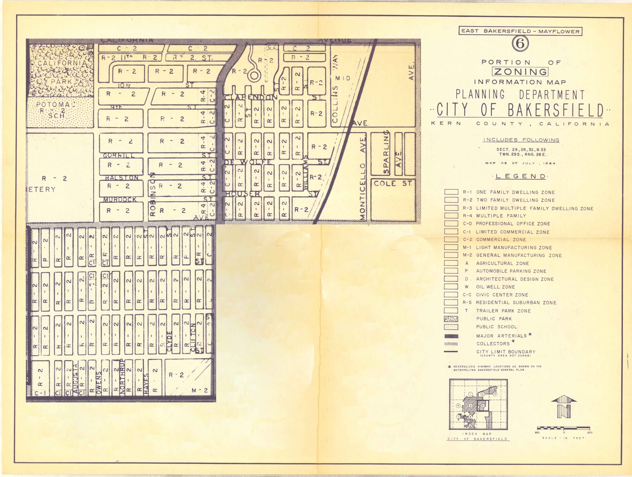
 Public Housing   –  Resources    –   Rumford Fair Housing Act     Suburban Expansion   –   Zoning 

Zoning- Development of Codes in Kern County

In the 1930s, the Kern County Board of Supervisors passed a series of zoning ordinances, introducing the first restrictions on land use and home development. On January 20, 1932, the Board passed Ordinance 244, instructing the planning commission to introduce zoning and district plans for applying to certain construction of buildings and alterations. The next ordinance (245 ) created the Planning Commission for the County of Kern. Ordinance 247, amended Ord. 244 and introduced restrictions on modifying or constructing smokestacks, flagpoles, tanks, radio stations, oil derricks, towers, and buildings in the unincorporated areas of the county.  

Ordnance 249 was the most comprehensive zoning law put into place in 1933, which created zone district sections 3A, 3B, 3C, 3D, and 3E. Ordinance 249 was the first land restriction to establish a “setback” standard, the set distance from home to the road, home desirability, and permitted building modifications.  

Definitions of the additions to the first Modern Zoning Code: 

3A- One family, two families, multiple dwellings, hotels, and auto camps.  

Uses: Schools, libraries, parks, playgrounds, churches, agriculture (except hogs), stores, shops, offices, retail, automotive sales (no dismantling or wrecking), and only indoor used car sales.  

3B- highway space, traffic movement, and pedestrian passage. Amended by Ordinance 269  

3C- Repairs to agricultural improvement, building, or repairs above $25 dollars require a permit. Modified by Ord 252. 

3D- Improvements under 3C require plans of elevations, not be obnoxious, be harmonious with the building of Kern County, and submit plans to the planning department.  

3E- Prescribe standardized forms for applications and appeals, allow for County enforcement by fine or jail, and allow for County abatement or removal of nuisance.  

3F- Added by Ord 252, establishing an interim district for housing in Castaic.  

3G- Added by Ord 257, establishing rules for mausoleums, cemeteries, and crematoriums. 

3H- Added by Ord 282, establishing residential blocks for single-family housing.  

3I- Added by Ord 282, 3H applies to Wasco.  

Ordinance 282 was the first law to include morals and public health: 

This ordinance is hereby declared to be an urgent measure necessary for the immediate preservation of the public health, morals, comfort, and general welfare, and shall take effect immediately. The conditions constituting such urgency are as follows: The Federal Housing Administration has undertaken to insure loans for the construction of adequate housing… Under the terms prescribed by the Federal Housing Administration, property is ineligible for such insured loans unless the neighborhood of such property is adequately protected against the instruction of uses which would impair the residential character of such neighborhoods” 1935.  

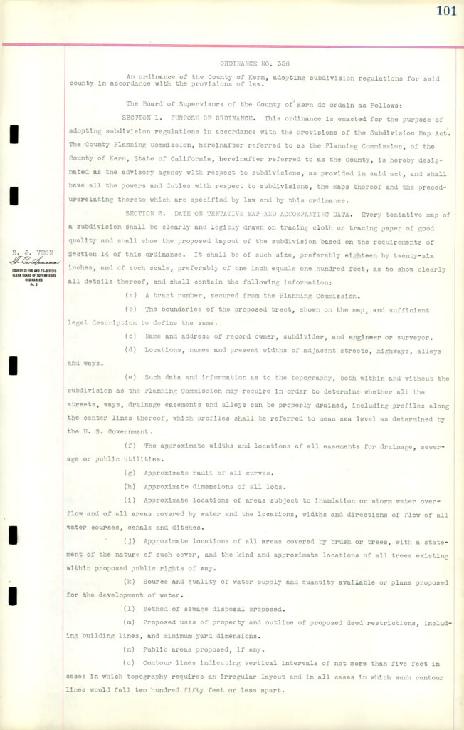
Later, Ordinances added more complex laws and shifted to modernity, setting in stone the tract era and standardized and suburban home building. Ordinance 327 added planning for districts, terms and procedures, regulations, building lines, and supervision for county homes. This was the most “modern” zoning ordinance in 1937.  This led to Ordinance 356, which established rules related to the “Subdivision Map Act” in 1940. This was the most comprehensive zoning law then, spanning 12 pages. The Subdivision Map Act of 1940 required local governments to establish regulations to guide subdivisions and grant powers to local governments to ensure that subdivisions occur (subjectively) in an orderly and responsible manner. Ordinance 354 included all the modern requirements for subdivision building: Tract number, boundaries, data, mapping, surveying, street names, recording, availability of modern amenities like gas/electricity/sanitary plumbing, master plans for subdivision with streets, and recommendations of parks, schools and public building sites for public use.  

This black-and-white typed document is titled at the top center: “ORDINANCE NO. 356.” It begins with the heading: “An ordinance of the County of Kern, adopting subdivision regulations for said county in accordance with the provisions of law.” The text states that the Board of Supervisors of the County of Kern ordains the following provisions. Section 1 – Purpose of Ordinance explains that the ordinance is enacted to adopt subdivision regulations in accordance with the Subdivision Map Act. It designates the County Planning Commission (referred to as the Planning Commission) as the advisory agency with respect to subdivisions and grants it the powers and duties specified by law and by the ordinance. Section 2 – Date on Tentative Map and Accompanying Data outlines detailed requirements for tentative subdivision maps. It specifies that each tentative map must be clearly and legibly drawn on tracing cloth or tracing paper of good quality and must show the proposed subdivision based on ordinance requirements. The map must be of specified size and scale and include detailed information such as: A tract number secured from the Planning Commission. Boundaries of the proposed tract with sufficient legal description. Name and address of the record owner, subdivider, and engineer or surveyor. Locations, names, and present widths of adjacent streets, highways, alleys, and ways. Topographical information necessary to determine drainage, including profiles along center lines and reference to mean sea level as determined by the U.S. Government. Approximate widths and locations of easements for drainage, sewerage, or public utilities. Approximate radii of curves. Approximate dimensions of all lots. Locations of areas subject to inundation or storm water overflow and the direction of flow of watercourses, canals, and ditches. Areas covered by brush or trees, including type and approximate locations. Source and quality of water supply and quantity available or proposed. Proposed method of sewage disposal. Proposed uses of property and outline of proposed deed restrictions, including building lines and minimum yard dimensions. Public areas proposed, if any. Contour lines indicating vertical intervals not more than five feet where required by topography. The page includes margin notations and a stamped signature block on the left margin referencing county officials. Overall, the document formally establishes procedural and technical standards governing subdivision development in Kern County, detailing the information required for planning review and approval.

Zoning- The Fight for Public Housing 1950s

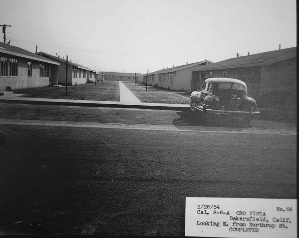
In December of 1950, the Sunset and Mayflower neighborhoods were annexed into the city of Bakersfield. The community had secured enough votes to be added to city boundaries, guaranteeing city services like sewer, street lights, paved roads, and trash pickup. The contract for Oro Vista was signed in early 1950, but the opening would not happen until 1954. The Bakersfield Realty Board supported Proposition 10 of 1950, which would require a majority of electors of a county or city to approve public housing. Oro Vista was planned in the Sunset community, adjacent to Adelante Vista.


“PUBLIC HOUSING PROJECTS. REQUIRING ELECTION TO ESTABLISH.” It identifies the measure as an Initiative Constitutional Amendment that would add Article XXXIV to the Constitution. A large “10” appears in the left margin, indicating the proposition number, with “YES” and “NO” boxes printed at the right. The summary states that the amendment: Requires approval by a majority of voters of a county or city, voting at an election, as a prerequisite to establishing any low-rent housing project by the State or by any city, county, district, authority, or other public body. Defines a low-rent housing project as living accommodations for persons of low income financed or assisted by the Federal Government or a state public body. Exempts any project subject to an existing contract between a state public body and the Federal Government. Below the heading is a section titled “Analysis by the Legislative Counsel.” It explains that the amendment would prohibit the development, construction, or acquisition of any low-rent housing project by the State or local public bodies unless approved by a majority vote of the electors in the city, town, or county where the project would be located. The analysis defines: “Low-rent housing project” as urban or rural dwellings, apartments, or other living accommodations for persons of low income, financed in whole or in part by the United States or its agencies, or by state or local public bodies, including projects where assistance is provided through labor, guarantees, or payment of liens. “Persons of low income” as those lacking sufficient income, as determined by the developing public body, to live in decent, safe, and sanitary dwellings without overcrowding and without financial assistance. The text notes that the amendment would be self-executing, though legislation to facilitate its operation may be enacted. At the bottom right is a section titled “Argument in Favor of Initiative Proposition No. 10.” It states that a “YES” vote is neither for nor against public housing itself, but for the future right of voters to decide “yes” or “no” when the community considers a public housing project.

A local Bakersfield realty agent sued on the basis of Proposition 10 and effectively stalled the building of Oro Vista in 1951. In January 1951, the City of Bakersfield entered in to a cooperation agreement with the Housing Authority of Kern County and later rescinded the agreement in March 1952, with the support and petition of the Bakersfield Realty Board. The Bakersfield earthquake happened in August of 1952. The city entered into a second cooperation agreement, reaffirming their cooperation in October 1952. The lawsuit and appeal carried into 1954, when it was established that Oro Vista was not subject to Proposition 10, since the contracts and loans were issued in 1949 and again in early 1950.

A separate injunction in 1954 also accused the City of Bakersfield of rezoning against the interest of the majority of the population. Mayflower and Sunset was Zoned R1 (One Family) to R2 (Two Family) housing. The second lawsuit determined that the State of California, under the Health and Safety Codes and The Housing Authority Law, had the power to change zoning without the opinion of the city’s electorate or public referendum, not limited to interference by municipal or county administration.

“PUBLIC HOUSING PROJECTS. REQUIRING ELECTION TO ESTABLISH.” It identifies the measure as an Initiative Constitutional Amendment that would add Article XXXIV to the Constitution. A large “10” appears in the left margin, indicating the proposition number, with “YES” and “NO” boxes printed at the right. The summary states that the amendment: Requires approval by a majority of voters of a county or city, voting at an election, as a prerequisite to establishing any low-rent housing project by the State or by any city, county, district, authority, or other public body. Defines a low-rent housing project as living accommodations for persons of low income financed or assisted by the Federal Government or a state public body. Exempts any project subject to an existing contract between a state public body and the Federal Government. Below the heading is a section titled “Analysis by the Legislative Counsel.” It explains that the amendment would prohibit the development, construction, or acquisition of any low-rent housing project by the State or local public bodies unless approved by a majority vote of the electors in the city, town, or county where the project would be located. The analysis defines: “Low-rent housing project” as urban or rural dwellings, apartments, or other living accommodations for persons of low income, financed in whole or in part by the United States or its agencies, or by state or local public bodies, including projects where assistance is provided through labor, guarantees, or payment of liens. “Persons of low income” as those lacking sufficient income, as determined by the developing public body, to live in decent, safe, and sanitary dwellings without overcrowding and without financial assistance. The text notes that the amendment would be self-executing, though legislation to facilitate its operation may be enacted. At the bottom right is a section titled “Argument in Favor of Initiative Proposition No. 10.” It states that a “YES” vote is neither for nor against public housing itself, but for the future right of voters to decide “yes” or “no” when the community considers a public housing project.

By February 1954, families had already started to move into Oro Vista.

“PORTION OF ZONING INFORMATION MAP PLANNING DEPARTMENT ‘CITY OF BAKERSFIELD’ KERN COUNTY, CALIFORNIA” At the top right corner, it is labeled “East Bakersfield – Mayflower” and marked with a circled 6, indicating map sheet number. The map includes the following legal description: Section 29, 28, 32 & 33 Township 29 South, Range 28 East Map as of July 1, 1964 The left half of the sheet contains a detailed block-by-block zoning layout of a residential neighborhood. Individual lots are labeled primarily R-2, indicating Two Family Dwelling Zone. Other zoning categories visible include: R-1 (One Family Dwelling Zone) R-4 (Limited Multiple Family Dwelling Zone) C-1 (Limited Commercial Zone) M-2 (General Manufacturing Zone) Street names visible include College Avenue, Monticello Avenue, Sparlin Avenue, Cole Street, and interior residential streets forming a regular grid pattern. Larger labeled features include: California Park Potomac School Cemetery The legend on the right lists zoning classifications and symbols, including: R-1: One Family Dwelling Zone R-2: Two Family Dwelling Zone R-4: Limited Multiple Family Dwelling Zone C-0: Professional Office Zone C-1: Limited Commercial Zone C-2: Commercial Zone M-1: Light Manufacturing Zone M-2: General Manufacturing Zone A: Agricultural Zone P: Automotive Parking Zone D: Architectural Design Zone OI: Well Zone CC: Civic Center Zone RS: Residential Suburban Zone T: Trailer Park Zone Additional symbols denote: Public Park Public School Major Arterials Collectors City Limits Boundary A small inset map at the bottom right shows the location of this zoning portion within the broader City of Bakersfield, along with a north arrow and scale in feet. The document visually reflects mid-20th-century municipal zoning classifications in the Mayflower area of East Bakersfield, showing a predominantly R-2 residential district with limited commercial and manufacturing zones at select edges.