Before 1938 – Buying on Contract – Covenants – Covenant Database – East Bakersfield
Education – Eminent Domain – Moving into a Neighborhood – Neighborhoods
Public Housing – Resources – Rumford Fair Housing Act – Suburban Expansion – Zoning
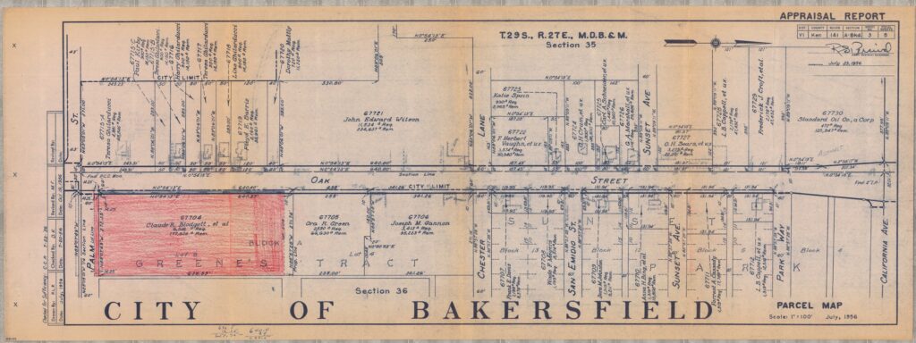
East Bakersfield
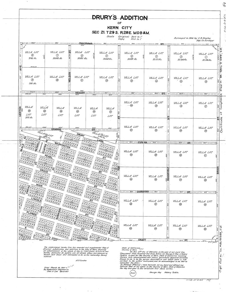
The development of East Bakersfield, north and east of Sumner, started with the redevelopment of older neighborhoods like the Drury Tract and subsequent additions (1893, 1896, and 1907), signifying the first East Bakersfield developments. By 1940, a new East Bakersfield had formed and was redeveloping. In 1939, and later, tracts like 1282 (1947), 1369 (1947), 1300 (1947), and 1095 (1939) were re-subdivided into the Drury Tract. All the new tracts had race restrictions.
Older neighborhoods like Monte Vista (established in 1916, covenant added in 1939) and La Naranja (established in 1916, covenant added in 1941) had restrictions added to the tract after the initial subdivision in 1916. This signified the new and renewed housing development during the FHA and HOLC New Deal housing policies. This also was the start of the revitalization of older white neighborhoods.
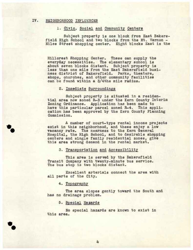
All these tract neighborhoods were in close proximity to East Bakersfield High School and Kern General Hospital. Along with education buildings and commercial centers, the “New” East Bakersfield’s growth started a new phase of housing development after the building of the Kern General Hospital in 1925, located on Flower Street. East High was a Works Progress Administration publicly funded project. It was completed in 1938. These two public buildings on the East Side started a proliferation of housing developments in the “new” East Bakersfield. These neighborhoods were attractive building sites due to the FHA recommendations of grading loan standards and restrictive policies introduced after 1938.
East Bakersfield was once an area of development and peak investment.
Grading was a standard of home finance introduced during the New Deal. Grading included proximity to schools, areas of commerce, hospitals, parks, and other characteristics of “desirability.” The closer to these commerce, recreation, and education centers landed the property higher on the scale of home loan finance opportunities. Restrictive covenants were recommended to limit the use of the home outside of living, standardized characteristics (like committee approvals), and racial restrictions. Housing between 1938 and 1950 reserved the best homes and financing for white communities all over America. This pattern is visible in East Bakersfield. By 1950, East Bakersfield was one of the most desirable areas to live in.
Major developments since 1925:
Kern General Hospital was relocated to East Bakersfield in 1925
East Bakersfield High was built in 1938
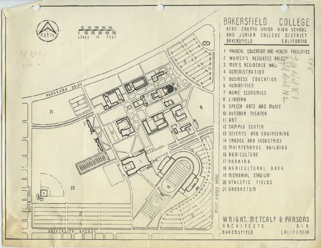
In April 1956, Bakersfield College was opened in East Bakersfield
East Bakersfield also became the new home of Bakersfield College which was outgrown. College officials expressed interest in relocating the campus away from Kern Union High School. In April 1956, Bakersfield College opened the campus after spending 8 million dollars on the new facilities on the Panoramic Bluffs. As the college opened, it created a new string of developments surrounding the campus. The college sustained the influence of East Bakersfield in the following decades. East Bakersfield experienced constant growth until recent history.
East Bakersfield was once an area with a high concentration of “White Only” Neighborhoods


In 1939, development was only in East Bakersfield. There was no real Southwest, West, or North West (like today). There were some colonies in Rosedale, Panama, and Gosford, but not a large urban population. The city ended at Oak and Brundage. After the 1950s, the city started to move SouthWest, West, and NorthWest. Bakersfield was not very diverse.

We can see some expansions in the West during the Covenant era, but not really until the 1960s. More expansion comes West of Bakersfield after West High was finished in 1965. Kern City was developed between 1961 and 1977 (retirement community in front of West High). Highway 99 divides the city in 1966 (Parallel to Oak/Wible), pushing the traffic and business west, replacing Union Ave as the old 99.
In 1966, the California Highway and Public Works magazine lauded the completion of the Interstate 5 and Highway 99 with no stop signs or lights. Previously, the old highway systems intersected city streets. In Bakersfield, Highway 99 ran through Union Avenue. After the completion, the highway was moved to run stop free parallel to Oak/Wible street. State Route 58 was completed to end at the Brundage and Oak Intersection. Previously State Route 466 was completed through Tehachapi, ending near Bakersfield, and later a freeway was constructed to run parallel to Brundage Lane. The 466 would run to the 99, making it State Signal Route 58. By 1966, the highway system would be complete, lauding, “Look Ma, No Lights!”
The city moves West

CSUB opened West of Bakersfield, in 1970.
In 1960, the Kern County Superintendent of Schools stated that Bakersfield was the largest isolated metropolitan in the United States to be without a senior college or university. In 1965, the California State Senate approved a proposal to build a higher education campus in Kern County. Kern State College was established, but a location for the college was not selected. The State College was to be the 19th campus in the California State College system, and it was also the only campus within a 100-mile radius to offer a four-year degree.
Senate Bill 75 established the planning of a State College in Kern County. The bill cited a 1959 report recommending a 4-year higher learning institution in the County of Kern. Senator Stiern argued to the California State Senate, “A great number of students would benefit from the addition of a new State College in Kern County since there are no four-year collegiate institutions in this area. College-going students from this area will continue to be isolated until a new campus is opened.” Stiern knew that there was a need for higher education. As an advocate for equal education, the proposed college was also to meet future growth and enrollment rates. In 1963, for every 1,000 students 535 high school graduates were enrolling in a higher education institution in California. This was close to the state average of 559 for every 1,000. With an estimated 3,000 projected enrollment for the new State College. Planning and management were left of the immediate future. The bill established, what would later become California State College Bakersfield and subsequently California State University, Bakersfield. The bill was co-authored by assembly members Williamson and Casey.
Proposed Sites for California State College, Bakersfield
Tejon Ranch was willing to donate 400 acres in the southeast area to build the new college. Situated near Arvin, California, “The White Wolf Grade: stretched between Bakersfield and Tehachapi and would have been a prime location because of the breathtaking view of the mountains and the easy access for commuters to Highway 58.
Another location, offered by George W. Nickel, Jr., was south of the Kern River by Highway 178 just east of Lake Ming Park.
The final location selected for the new college site was offered as a gift by Kern County Land Company. The land was donated to the state of California in 1962 with the express purpose of having a state college campus in Bakersfield. The campus would be situated on a 370-acre site in southwest Bakersfield on Stockdale Highway, approximately five miles west of central Bakersfield.
The Stockdale location was the only site to offer adjacent housing and development support. The maps presented to building the site had listed churches, industrial districts, a high school, and new housing by the Stockdale Development Corporation.

The college becomes a reference for urban investment.

Coming into a Modern East Bakersfield
In 1988, the East Hills Mall opened; it subsequently was demolished in 2021. The East Hills Mall’s failure signifies the development pivot to the Northwest, West, and Southwest. This is also the period of rapid growth of Hispanic and Black communities in East Bakersfield, outside of Mayflower and Sunset. By 2020, East Bakersfield had Hispanic-dominant areas. Some are now predominantly Hispanic. East Bakersfield was the first site of a Hispanic grocery supermarket, Pro’s Ranch Market, opening in the 2000s at the intersection of Mt. Vernon and Niles Street. Now, there are Superior Grocery stores, Vallarta Grocery stores, and many smaller markets that have opened as they see Hispanic residents as stakeholders in cultural investment, including ethnic foods. Most recently, a Vallarta Grocery store opened on Rosedale Highway, a predominantly white area, and in the same parking lot where there was a confrontation between Alt-Right Supporters of former President Trump and anti-trump activists. The most recent investment in the Southwest has been Vallarta’s announcement of a new proposed grocery store at the intersections of Panama and Old River, where new homes are under development with prices advertised right below $500,000. This represents Hispanics at the pinnacle of investment, where chains and Hispanic serving stores see Latina/o/x as stakeholders in areas that are not at the poverty or affordable new construction income level.
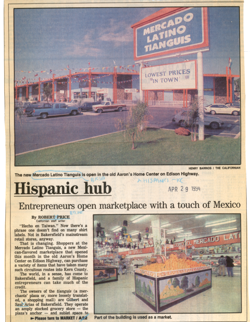
Prior to the rise of Hispanic supermarkets, Mercado Latino opened on April 10, 1994, at California and Chamberlain Avenues. Mercado Latino is a diverse shopping area where small business owners rent a storefront and sell inside and outdoors in the building area. Previously, the building had been an Aaron’s Home Center. The original Mercado Latino was a grocery store with sublet space for independent merchants. Merchandise included tools, music, balloons, decorations, shoes, clothes, jewelry, and Mexican food. April 2024 will be its 30th anniversary.
Current: Diverse East Bakersfield

A place of less economic opportunity

Residents of East Bakersfield want investment
