Unequal Suburban Development

 Before 1938    –  Buying on Contract     Covenants  –   Covenant Database   –  East Bakersfield     

    Education    –   Eminent Domain     –     Moving into a Neighborhood   –    Neighborhoods     

 Public Housing   –  Resources    –   Rumford Fair Housing Act     Suburban Expansion   –   Zoning 

Unequal Suburban Development

his black-and-white magazine page is titled in large capital letters: “HOMES: BUILT TO TAKE ADVANTAGE OF CLIMATE.” A short introductory paragraph beneath the title explains that the “wall of glass” building idea finds ideal conditions in Bakersfield and that many homes built in the previous decade used this style. It references air conditioning, swimming pools, and patios as common features in a city where the average family income exceeds seven thousand dollars per year.The upper photograph shows the exterior of a single-story mid-century modern home. The house features a dramatic slanted roofline and a large glass wall composed of tall, vertical window panels extending from near the floor to the ceiling. The glass façade faces a landscaped yard with shrubs and flowering plants in the foreground. A secondary wing of the house extends to the right, with clean horizontal lines and minimal ornamentation. The design emphasizes openness, light, and connection to the outdoors. The lower photograph shows the interior living room of the same home. A full wall of floor-to-ceiling glass windows lines the left side of the room, revealing an expansive outdoor view of flat land and distant horizon. The ceiling is angled upward, following the roofline, and appears to be finished in narrow, evenly spaced panels. The room contains mid-century furnishings: a long upholstered sofa, a round coffee table with books and a decorative bowl, a low side table, and a built-in shelving unit filled with books at the back wall. A brick fireplace with a long, raised hearth runs along the right side. Indoor plants are placed near the windows, reinforcing the indoor–outdoor aesthetic. The page presents mid-twentieth-century residential architecture in Bakersfield as climate-responsive, modern, and prosperous, emphasizing glass walls, open plans, and leisure-oriented features such as patios and pools.
“homes built to take advantage of the climate,” Earthquake Vertical File, Jack McGuire Local History Room, Beale Memorial Library

Starting in the 1940s, urban housing communities began construction in a new fashion, dubbed the modern urban and suburban model. The communities were farther away from downtowns, including older and centralized business districts. With time, these communities also created their districts to serve the needs of these auxiliary communities, resulting in new needs and investment in distant communities.

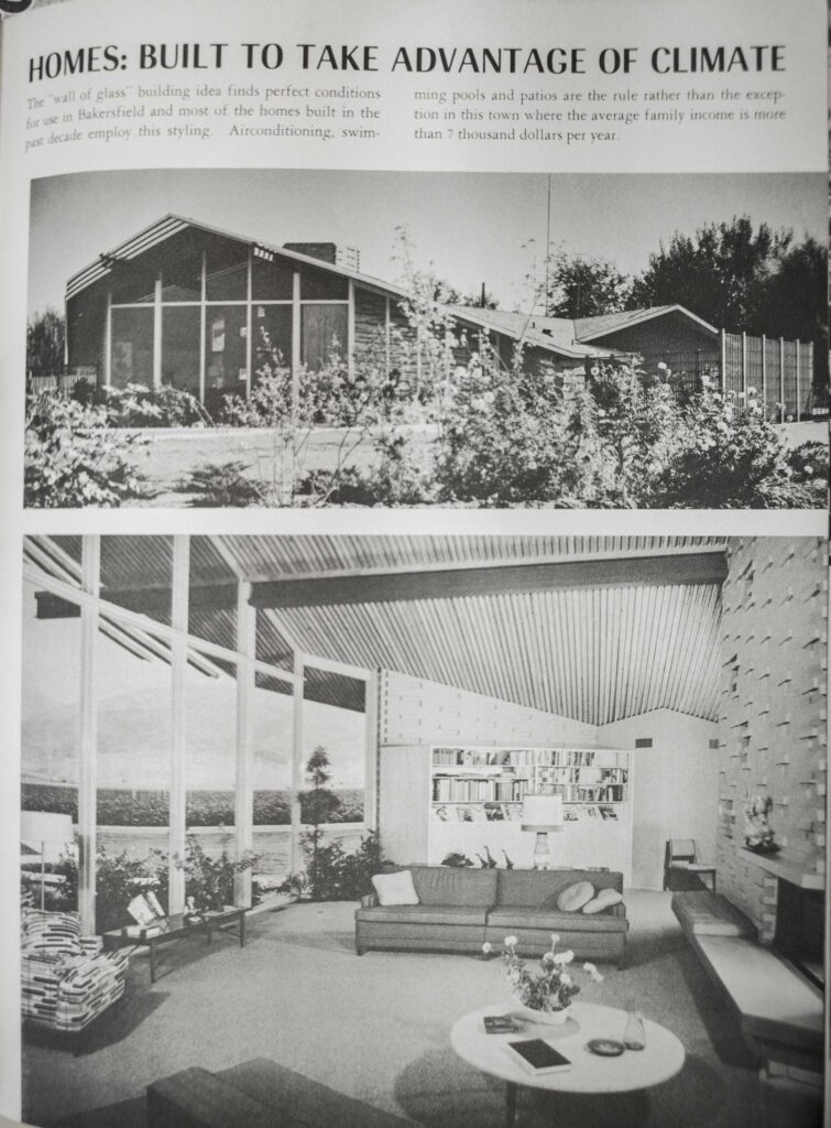
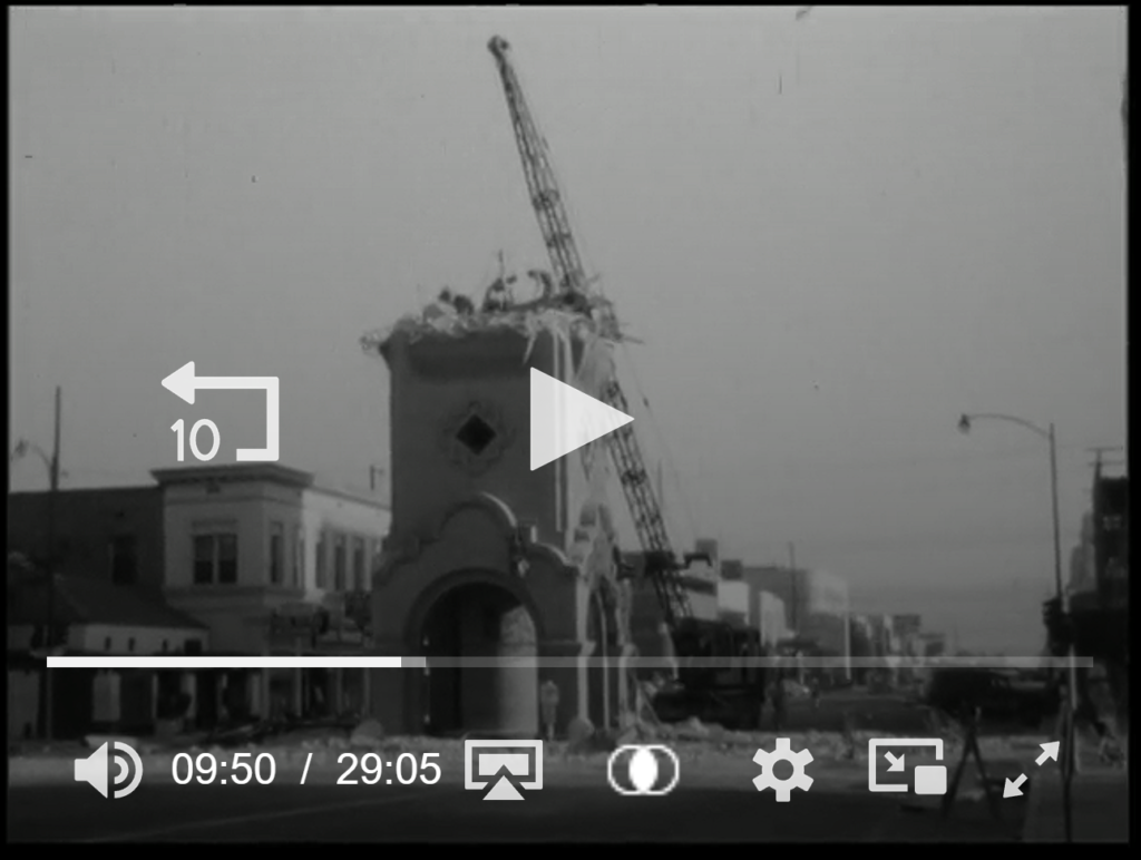
Bakersfield was a small but rapidly urbanizing city during this time. Between 1930s and 1950, Bakersfield had seen expansion to East Bakersfield, and expansion South-west Bakersfield (Ming and Stine). Bakersfield remains unique to western suburban history. While other older downtowns faced decline and lacked transformation, Bakersfield took the opportunity to rebuild and reimage it’s city scape after the 1952 earthquake. By the late 1950s, the city had a new court building, library, remodeled administrative buildings, an uplift to downtown, Bakersfield College was moved to its present day location (Panorama Drive), and all the elementary and intermediate schools were rebuilt. Click to view the E.E. Wonderly photographs of the damage cause to downtown Bakersfield.


Cruz, Donato. “‘America’s Newest City’: 1950s Bakersfield and the Making of the Modern Suburban Segregated Landscape.” ProQuest Thesis Publishing, 2020.


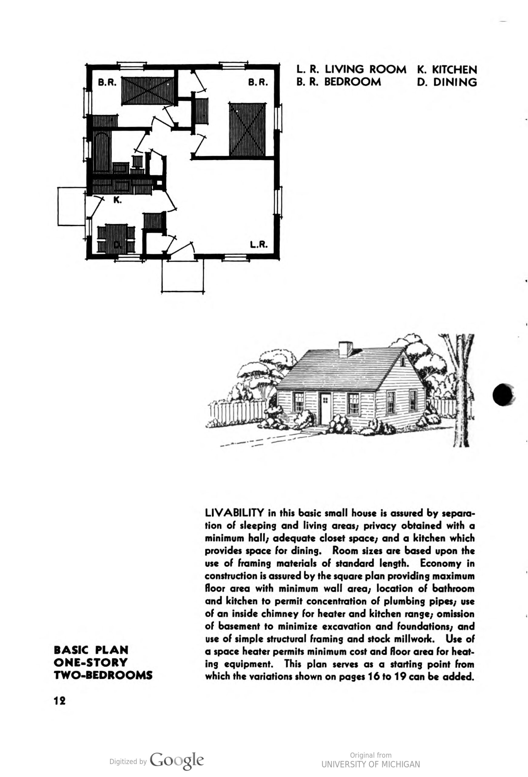
Federal Housing Administration, Principles of Planning Small Houses

1952 Earthquake: “Touring Downtown; pictures of Bakersfield immediately after earthquake”


This black-and-white image appears to be a still frame from a documentary or archival film. A partially demolished masonry building stands in the center of a downtown street. The structure has a tall façade with a decorative arched entrance at ground level and a small diamond-shaped window above. The upper portion of the building is broken and jagged, with debris visible along the roofline. A tall crane rises behind the building, its boom angled diagonally upward. The crane’s presence indicates active demolition. Rubble is scattered at the base of the structure, suggesting that portions of the building have already been removed. On either side of the building, low-rise commercial storefronts line the street, extending into the distance. Utility poles and streetlights are visible along the sidewalk. The street appears mostly empty of traffic, reinforcing the focus on the demolition scene. Overlayed on the image are video playback controls, including a central play button, a progress bar at the bottom, and time markers indicating approximately 9 minutes and 50 seconds into a 29-minute and 5-second video. These on-screen graphics confirm that the image is captured from a digital video interface rather than a standalone photograph. The overall scene documents urban change in progress, capturing the removal of an older downtown structure as part of redevelopment or street modification efforts.


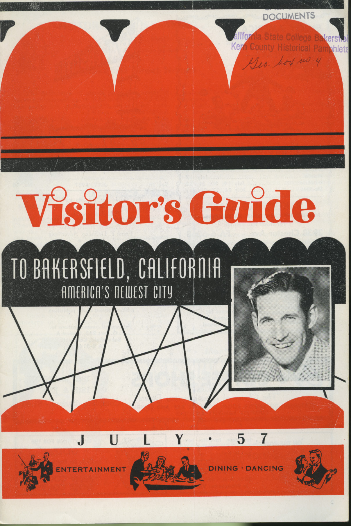
After the 1952 Earthquake, America’s Newest City Bakersfield

On August 22, 1952, an earthquake struck in proximity to the city of Bakersfield and by estimated accounts, generated about $10 million to $30 million in damage. There were reported fires, however, none further endangered the city and firefighters were called to dig out people who were trapped in collapsed buildings. As the days went on, engineers and contractors were hired by the City Inspector and instructed to survey and declare buildings unsafe. The city did not establish a policy on how homes should be repaired, only referring them to the City’s existing building code. The City of Bakersfield took no financial obligation to rebuild or renovate housing, nor was its intention recourse to help homeowners in the disaster. While no figures were reported for housing damage, official reports did mention housing. The “Bulletin of the Seismological Society of America: An Engineering Study of Southern Californian Earthquakes of July 21, 1952, and its Aftershocks,” reported on the types of damage homes sustained. The Engineering Study reported that wooden framed houses fell off their foundations if they lacked foundation bolts. 

The city that rose after the earthquake became an invitation for a “white economy” and exclusively elite housing. Shortly before the “America’s Newest City” platform, welcome housing booklets were distributed to new homeowners. The welcome booklet included coupons, welcome messages from business owners, and a list of babysitters. This booklet also featured a personal and a very warm welcome from the Mayor, Manuel J. Carnakis. It read, “A hearty welcome to you from the City of Bakersfield. May your stay be long and happy… We hope you will join us with our civic affairs and social affairs. Get acquainted with our municipal problems. You are invited to attend meetings of the city council…” As the pamphlet welcomed the new homeowners, there was no mention of race relations, and yet, the map provided excluded the Mayflower and Sunset Tracts. The welcome seemingly was not intended for the minority residents who were segregated. 

This image shows the front cover of a mid-century promotional booklet titled Visitor’s Guide to Bakersfield, California: America’s Newest City. The design uses bold red, black, and white graphics characteristic of 1950s print aesthetics. Across the top, stylized red scalloped shapes stretch horizontally, with small black decorative accents above. Near the upper right corner is a faint archival stamp reading “California State College Bakersfield – Kern County Historical Pamphlets,” along with a handwritten notation that appears to read “Geo. box no. 4.” Centered on the cover in large red serif lettering is the title: “Visitor’s Guide.” Below it, in white capital letters against a black background, is the subtitle: “TO BAKERSFIELD, CALIFORNIA – AMERICA’S NEWEST CITY.” Thin black geometric lines crisscross the middle portion of the design, adding a modern, abstract visual element. On the right side of the cover is a black-and-white portrait photograph of a smiling young white man with neatly combed dark hair. He wears a patterned jacket and collared shirt. The portrait is framed in a rectangular border integrated into the graphic layout. Near the bottom of the cover, the date appears as “JULY ’57.” Along the lower red band are small illustrated silhouettes depicting leisure activities. On the left, figures appear to be performing or entertaining; in the center, people are shown dining at a table; on the right, a couple appears to be dancing. Text beneath these illustrations reads “ENTERTAINMENT” and “DINING – DANCING.” The overall design emphasizes Bakersfield as a modern, growing, and socially vibrant city in 1957, highlighting nightlife, recreation, and hospitality as key attractions.

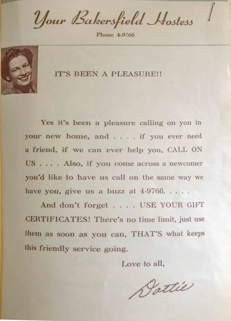
The city also had a Bakersfield Hostess, Dottie Hiatt. Her message read, “Yes it’s been a pleasure calling on you in your new home, and… if you ever need a friend, if we can ever help you, CALL ON US….” The newest homes were not in Mayflower or Sunset, but in the new East, South and West Bakersfield. By late 1952, Bakersfield College was already being redesigned and planned to be relocated to the new North-east Bakersfield. Campus plans were drafted in 1951, but the economic urban renewal investment of the post-earthquake accelerated its relocation. By 1954, most of the college’s buildings were approved for construction, and a 3.4-million-dollar contract was already awarded. New housing and higher education were being built for the elite communities. The college, while in the north-east, was not built to serve the minority and poor neighborhoods, a geographic feature that deterred public access to education and economic uplift. After the expansive urban renewal of the mid-1950s, Kern County advertised its public education as, “Good Schools, Good Citizens,” which included 133 elementary schools, 18 high schools, and two junior colleges. 

This image shows a vertically oriented printed flyer titled “Your Bakersfield Hostess” with the phone number “Phone 4-9766” printed beneath the heading. The title is written in a decorative script font at the top of the page. In the upper left corner is a small black-and-white portrait of a smiling white woman with short, styled hair, wearing a blouse. The photograph is inset into the page and aligned to the left margin. Centered below the heading appears the bold statement: “IT’S BEEN A PLEASURE!!” in capital letters. The body text reads: “Yes it’s been a pleasure calling on you in your new home, and . . . . if you ever need a friend, if we can ever help you, CALL ON US . . . . Also, if you come across a newcomer you’d like to have us call on the same way we have you, give us a buzz at 4-9766. . . . And don’t forget . . . . USE YOUR GIFT CERTIFICATES! There’s no time limit, just use them as soon as you can, THAT’S what keeps this friendly service going.” At the bottom of the page, the closing reads: “Love to all,” followed by a handwritten-style signature that reads “Dottie.” The flyer appears to promote a mid-20th-century newcomer or welcome service in Bakersfield, encouraging new residents to call for assistance and to use promotional gift certificates provided through the program.

On August 12, 1953, President Eisenhower addressed a message to the citizens of the City of Bakersfield, as the urban renewal was already visible. Then-President Eisenhower wrote, addressing the noticeable physical and financial changes,  

“Senator Knowland has reminded me that approximately one year has passed since your community suffered the devastation of a major earthquake. He has reminded me also with understandable pride- of the speed and extraordinary community cooperation with which you have rebuilt your county. I gladly take this opportunity to salute the courage and resourcefulness shown by Bakersfield Citizens. I share Senator Knowland’s pride in these remarkable accomplishments of our fellow Americans. May Bakersfield continue to thrive through the years ahead. I am confident that it will.  

William Knowland had been a long associate of Bakersfield. As a visitor to the area, it was natural for Oakland’s Senator to speak of the condition of Bakersfield. From 1953 to 1955, Senator Knowland was also the Senate Majority Leader and the Minority leader from 1955 to 1959. He was well-known in California and national politics, and as we saw in the previous chapter, an opponent of public housing. 

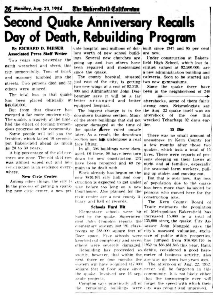
The City of Bakersfield was taking advantage of the earthquake in many ways. The Bakersfield Californian reported on August 23 1954 that a high percentage of “eyesore” buildings were gone. In the same light, the old downtown’s skid row was almost gone, following new construction. The city took full advantage of removing the sores they disapproved of and invested in removing buildings. The other history missing was how downtown redevelopment displaced people who were living nearby or in downtown. The impact proved to visitors that Bakersfield was a city that rebuilt in a “positive” direction and took an active responsibility in transforming.  This is the only citation that suggests the removal of the Bakersfield Chinatowns, as city leaders remodeled downtown. 

This black-and-white newspaper page from The Bakersfield Californian, dated Monday, August 23, 1954 (page 26), features the large headline: “Second Quake Anniversary Recalls Day of Death, Rebuilding Program.” The article is written by Richard D. Bieser, identified as an Associated Press staff writer. The article opens by recalling the earthquake that struck two years earlier, describing how the earth “wrenched and shook this city unmercifully,” with brick and masonry buildings collapsing into the streets. It reports that two persons died and 32 were injured. The total financial loss from the quake is stated as $48,650,000. The story emphasizes that, despite the tragedy, the disaster marked a turning point in Bakersfield’s development. It describes the transformation of the city’s downtown business district, noting that many buildings damaged in the quake were later ruled unsafe and replaced. The article reports that 285 buildings were damaged, 90 were demolished for new construction, 237 were repaired, and 69 remained to be addressed at the time of publication. Several sections describe rebuilding efforts: New Civic Center: Plans for a new civic center, including a new city hall and county library and hall of records. Hospitals: The county hospital east of the city is expanding with two new wings costing $2,518,000, described as better arranged and better equipped. Schools Hard Hit: Elementary schools were heavily damaged. Superintendent John Compton reports the loss of 191 classrooms totaling 286,000 square feet of floor space. Five schools were knocked out completely, and seven were severely damaged. The rebuilding program aimed to add 417,000 square feet of floor space since the quake. Business and Construction: Construction activity and modernization are described as widespread. The article notes that 85 percent of buildings built since 1947 were new. Aftershocks and Death Toll: It references approximately 240 aftershocks and recalls that the August 22 quake itself was an aftershock of the earlier quake that devastated Tehachapi. The article also reports population growth, stating that Metropolitan Bakersfield’s population had increased by 15,000 to a total of 135,000 since the quake. Assessed valuation had risen from $36,820,110 in 1952 to $66,681,845 two years later, indicating economic recovery and expansion. The piece concludes that while the earthquake of August 22, 1952, would never be forgotten, the rebuilding effort reshaped Bakersfield into a more modern city.

This circular-cropped image is a detailed section of a Sanborn Fire Insurance map depicting part of Bakersfield’s historic Chinatown district. The map shows numbered blocks including Block 191 at the top and Block 206 at the bottom, with 21st Street running horizontally through the center. Side streets labeled 15th Street and 21st Street are visible, along with lot lines, property dimensions, and building footprints.The buildings are shaded in pink, indicating brick or masonry construction, with yellow highlights marking structural features or modifications. Individual structures are labeled with abbreviations such as “REST.” (restaurant), “ROOMS,” and “CARD RM.” (card room). One building in the upper left is labeled “Chinese Society,” and another in the lower portion reads “J.W.G. Shuey’s Chinese Clubhouse,” noted as reinforced concrete posts and girders. Additional annotations indicate uses such as “S.W.” (likely sidewalk or structural wall), “Auto Rep.” (auto repair), and “Used Auto Sales.” The map includes detailed measurements of building widths and lot depths in feet, showing parcel boundaries and the arrangement of narrow commercial storefronts typical of early 20th-century urban development. Structural features such as walls, doors, and interior partitions are outlined, reflecting the fire insurance purpose of the map. Overall, this document visually records the spatial layout, density, and mixed commercial uses of Bakersfield’s Chinatown area, documenting the presence of Chinese associations, clubs, restaurants, and rooming houses within the city’s downtown grid.
Chinatown, Sanborn Fire Insurance Map, 1950 LOC https://www.loc.gov/resource/g4364bm.g4364bm_g00404195101/?sp=17&st=image&r=-0.018,0.324,0.654,0.394,0

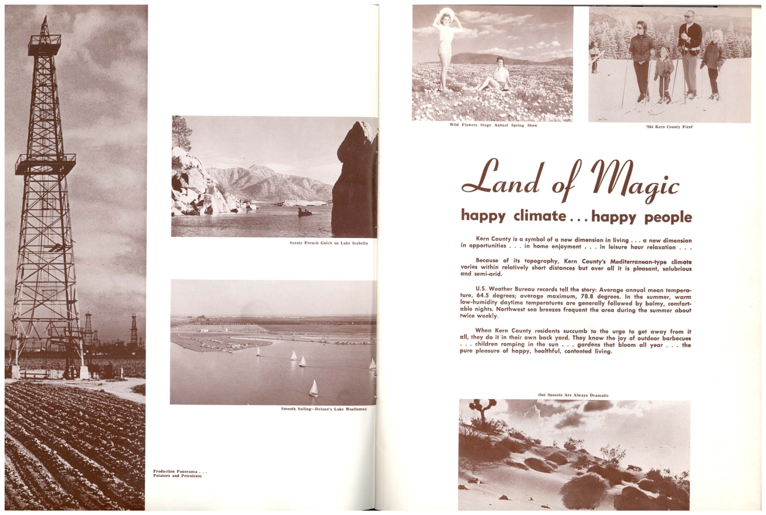
While the city of Bakersfield was rebranded as “America’s Newest City,” the County of Kern was marketed as the “Land of Magic.” These platforms of investments included new investments in tourism, business, education, and other economic transformations that did not include neighborhoods of color.

This circular-cropped image is a detailed section of a Sanborn Fire Insurance map depicting part of Bakersfield’s historic Chinatown district. The map shows numbered blocks including Block 191 at the top and Block 206 at the bottom, with 21st Street running horizontally through the center. Side streets labeled 15th Street and 21st Street are visible, along with lot lines, property dimensions, and building footprints. The buildings are shaded in pink, indicating brick or masonry construction, with yellow highlights marking structural features or modifications. Individual structures are labeled with abbreviations such as “REST.” (restaurant), “ROOMS,” and “CARD RM.” (card room). One building in the upper left is labeled “Chinese Society,” and another in the lower portion reads “J.W.G. Shuey’s Chinese Clubhouse,” noted as reinforced concrete posts and girders. Additional annotations indicate uses such as “S.W.” (likely sidewalk or structural wall), “Auto Rep.” (auto repair), and “Used Auto Sales.” The map includes detailed measurements of building widths and lot depths in feet, showing parcel boundaries and the arrangement of narrow commercial storefronts typical of early 20th-century urban development. Structural features such as walls, doors, and interior partitions are outlined, reflecting the fire insurance purpose of the map. Overall, this document visually records the spatial layout, density, and mixed commercial uses of Bakersfield’s Chinatown area, documenting the presence of Chinese associations, clubs, restaurants, and rooming houses within the city’s downtown grid.


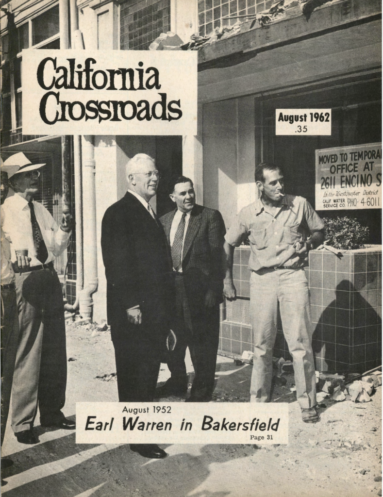
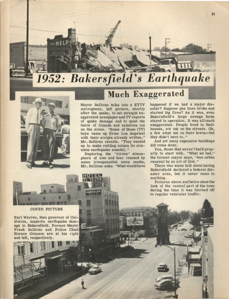
On the tenth anniversary of the 1952 earthquake, California Crossroads dedicated its cover feature and a full-page spread to the remembrance of the earthquake and rebirth of the City of Bakersfield. The photograph on the cover was of then-Governor of California, Earl Warren. He was photographed near a building with small amounts of rubble still on the ground. On his left was former Mayor Frank Sullivan, and on his right was Police Chief Horace Grayson. Frank Sullivan, who was mayor during the earthquake, gave some distinctive remarks on the anniversary of the transformation of the city. He recalled his interactions with out-of-town media and described the exchange as a circus, stating, “They wanted us to make rattling noises (to simulate earthquake sounds).” He seemed to be displeased in his reflection of the events that had “destroyed” the town. Sullivan asked, “‘What would have happened if we had a major disaster?’” Regardless of Sullivan’s calm demeanor, he was reflecting ten years after the initial rebuilding of Bakersfield, and as a previous mayor. During his reflection, he commented, “What we had was urban renewal by an act of God.” Those words resonated with the platform to rebuild Bakersfield, and launched the new marketing campaign of “Bakersfield, America’s Newest City.” The act of God was Sullivan’s opportunity to rebuild and reimagine the city since he was mayor in from 1950 to 1952 and again in 1957 to 1961. He took full advantage of it.


This black-and-white magazine cover displays the title California Crossroads prominently in large serif lettering at the upper left. In the upper right corner, a small box reads “August 1962” with the price listed as “.35.” The main photograph shows four adult men standing on a sidewalk in front of a commercial building with tiled exterior walls. Debris and broken masonry are visible near the building façade, suggesting recent construction, renovation, or damage. One man on the far left wears a light-colored hat and tie and gestures with his hand. Next to him stands an older man in a dark suit and tie—identified by the cover caption as Earl Warren—smiling slightly and facing toward the right. Two other men stand nearby: one in a suit and tie and another in short sleeves with a cigarette in his mouth, leaning casually against the tiled wall. Behind them, a window sign reads “August 1962 .35.” Another posted sign in the background reads: “Moved to Temporary Office at 2611 Encino St., in the Westchester District, Cal Water Dept., Service Co., Ph. 4-6011.” At the bottom of the cover, a caption states: “August 1952 Earl Warren in Bakersfield – Page 31.” The image therefore references an earlier visit by Warren a decade prior to the publication date. The overall composition situates a prominent public figure in an urban Bakersfield streetscape, visually linking local history, civic leadership, and public development within the magazine’s broader regional focus. This black-and-white magazine page is titled in large bold lettering: “1952: Bakersfield’s Earthquake” with the subheading “Much Exaggerated.” The layout combines headline text, columns of narrative, and several photographs documenting earthquake damage and its aftermath. At the top of the page is a photograph of a collapsed commercial building with debris spilling into the street. A crane stands behind the structure, and a truck is parked nearby, suggesting active cleanup or demolition. A partially visible storefront sign reads “The Help.” Rubble and broken roofing materials dominate the foreground, emphasizing structural failure. Below the headline, a column of text discusses media coverage of the earthquake. It references Mayor Frank Sullivan speaking into a KTTV microphone shortly after the quake, attempting to counter exaggerated reports of destruction. The article questions how the city would have responded to a more severe disaster and notes that gas lines and major infrastructure remained largely intact. To the left is a smaller inset photograph showing two men standing outdoors. The caption identifies the cover image context: “Earl Warren, then governor of California, inspects earthquake damage in Bakersfield. Former Mayor Frank Sullivan and Police Chief Horace Grayson are at his right and left, respectively.” The men wear light-colored suits and hats, standing beside a parked car. The lower half of the page contains a large photograph of downtown Bakersfield. Visible landmarks include the Hotel El Tejon and a central clock tower in the street median. The street appears partially blocked to regular traffic, with a few cars parked and minimal pedestrian presence. The image conveys both damage and controlled recovery. The article text notes that many expensive buildings collapsed, particularly those not constructed properly, and references discussions of urban renewal following the disaster. It suggests that the quake accelerated redevelopment in parts of the city. Overall, the page combines journalistic reflection, civic commentary, and visual documentation to frame the 1952 earthquake as both destructive and transformative in Bakersfield’s urban history.

August Volume IV No.8, 1962. California Crossroads Magazine, 2019-005. California State University, Bakersfield, Walter W. Stiern Library-Historical Research Center. https://archives.csub.edu/repositories/3/archival_objects/4799 Accessed February 09, 2024.